 AVYCAST
Queenstown — Bollettino valanghe
Il pericolo valanghe in Queenstown (Nuova Zelanda) è 3 — Marcato, valido per domenica 27 settembre 2026. Pubblicato da New Zealand Avalanche Advisory.
Le lastre da vento recentemente formate saranno reattive questa mattina. Evitare zone di carico evidente e di scarsa portata di discesa. Sarà necessario un'analisi accurata del terreno e decisioni esperte per un viaggio sicuro in montagna. Anche se freddo, saranno possibili valanghe di slittamento di tipo umido e sciolto se il sole farà capolino.
Pericolo per quota
Problemi valanghivi attivi
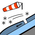

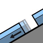
Nessun incidente segnalato ieri. Venti di maestrale NW in intensificazione, in tendenza SW al mattino. La neve si attenua lentamente durante la giornata. Temperature fredde con il FAFL che scende a 700m. Le zone dove il vento ha spazzato via la neve fresca saranno molto scivolose. I pendii esposti a ovest saranno aree da evitare.
10-20cm di neve fresca durante la notte a basse quote. Probabile accumulo fino a 80cm sui pendii di riparo. Si prevede un buon legame con la vecchia superficie calda e umida nella maggior parte delle zone. Questo si sovrappone a un manto nevoso superiore umido nella maggior parte delle aree. Le zone esposte al vento e prive di neve saranno gelate e ghiacciate oggi. Il manto nevoso medio e inferiore è generalmente ben consolidato, ma le aree sottili stanno diventando umide e poco consolidate a quote medie e basse. Si sono osservate crepe di scivolamento e buckling su pendii soleggiati a quote più basse.
Fonte: New Zealand Avalanche Advisory · Vedi bollettino originale
Tradotto (EN)
Domande frequenti
Che cosa significa il grado di pericolo valanghe 3 (Marcato)?
Condizioni critiche — una singola persona può staccare valanghe su molti pendii ripidi; è indispensabile una scelta prudente dell'itinerario.
Con quale frequenza viene aggiornato il bollettino di Queenstown?
Avycast aggiorna ogni ora; New Zealand Avalanche Advisory ripubblica il bollettino di solito una volta al giorno durante la stagione.
Chi pubblica il bollettino valanghe di Queenstown?
New Zealand Avalanche Advisory — il servizio valanghe ufficiale. Avycast lo aggrega e lo traduce; consulta sempre il bollettino originale.
Regioni vicine
- Wanaka · 28 km
- Aspiring · 53 km
- Fiordland · 91 km
- Ohau · 101 km
- Aoraki/Mt Cook · 173 km
- Two Thumbs · 188 km