 AVYCAST
Wanaka — Bollettino valanghe
Il pericolo valanghe in Wanaka (Nuova Zelanda) è 3 — Marcato, valido per lunedì 28 settembre 2026. Pubblicato da New Zealand Avalanche Advisory.
Previste nevicate a quote bassi e venti da sud-ovest forti o burrascosi. È probabile lo sviluppo di lastra da vento. Stare attenti alla neve soffiata e mantenersi lontani dalle zone in cui si accumula.
Pericolo per quota
Problemi valanghivi attivi
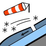

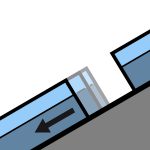
Le osservazioni sono state ostacolate nelle ultime 24 ore dall’attività di tempesta. Valanghe umide (valanghe di neve sciolta, lastra umida e valanga di slittamento) di alcuni giorni fa. Un escursionista ha accidentalmente innescato una valanga di neve sciolta di dimensione 1,5 venerdì (18/9) nel backcountry vicino a Treble Cone. Un ciclo di valanghe naturali di neve umida (dimensione 1 e 1,5) si è verificato giovedì e venerdì, man mano che la giornata si riscaldava. Se si osservano prove di valanghe nel backcountry, si prega di inserire un’Osservazione Pubblica. Domenica - nevicate durante la notte di sabato fino a 400 m. Le nevicate si attenuano durante la mattina. Venti da nord-ovest che si trasformano in sud-ovest e si intensificano fino a raffiche di burrasca alle quote superiori. Livello di congelamento - 1700 m, in rapido calo fino a 800 m prima dell’alba. Le condizioni primaverili (fusione/gelatura) generalmente comportano un rischio di scivolamento elevato. Croste scivolose e zone ghiacciate sono state diffuse, soprattutto sotto circa 1850 m. Si consiglia di portare ramponi da sci e/o un piccozza e ramponi.
Una combinazione di pioggia e neve nelle ultime 24 ore (15 mm nell’Albert Burn). Il manto nevoso sottostante sopra circa 1800 m è per lo più ben consolidato. È probabile che il manto nevoso trattenga una quantità significativa di umidità sotto circa 1800 m. Prima della tempesta più recente, si stava verificando un ciclo tipico di fusione/gelatura primaverile.
Fonte: New Zealand Avalanche Advisory · Vedi bollettino originale
Tradotto (EN)
Domande frequenti
Che cosa significa il grado di pericolo valanghe 3 (Marcato)?
Condizioni critiche — una singola persona può staccare valanghe su molti pendii ripidi; è indispensabile una scelta prudente dell'itinerario.
Con quale frequenza viene aggiornato il bollettino di Wanaka?
Avycast aggiorna ogni ora; New Zealand Avalanche Advisory ripubblica il bollettino di solito una volta al giorno durante la stagione.
Chi pubblica il bollettino valanghe di Wanaka?
New Zealand Avalanche Advisory — il servizio valanghe ufficiale. Avycast lo aggrega e lo traduce; consulta sempre il bollettino originale.
Regioni vicine
- Aspiring · 25 km
- Queenstown · 28 km
- Ohau · 90 km
- Fiordland · 98 km
- Aoraki/Mt Cook · 156 km
- Two Thumbs · 176 km