 AVYCAST
Wanaka — Bulletin d'avalanche
Le danger d'avalanche en Wanaka (Nouvelle-Zélande) est 3 — Marqué, valable pour lundi 28 septembre 2026. Publié par New Zealand Avalanche Advisory.
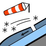
De la neige jusqu’à basse altitude et des vents forts à tempête de sud-ouest sont prévus. Le développement de plaques à vent est probable. Soyez attentifs à la neige soufflée et évitez les zones où elle s’accumule.
Danger par altitude
Problèmes d'avalanches actifs

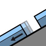
Les observations ont été entravées au cours des dernières 24 heures par l’activité orageuse. Des coulées humides (coulées humides libres, plaques à neige récente et glissement) il y a quelques jours. Un skieur a accidentellement déclenché une coulée humide libre de taille 1,5 vendredi (18/9) en hors-piste près de Treble Cone. Un cycle de coulées humides naturelles (taille 1 et 1,5) s’est produit jeudi et vendredi à mesure que la journée se réchauffait. Si vous constatez des preuves d’avalanches en hors-piste, veuillez faire une observation publique. Dimanche - neige pendant la nuit de samedi jusqu’à 400 m d’altitude. Les précipitations en neige diminuent durant la matinée. Les vents du nord-ouest tournent au sud-ouest et atteignent la force de tempête en haute altitude. Le niveau de gel - 1700 m, chute rapidement à 800 m avant l’aube. Les conditions de printemps (dégel/refroidissement) entraînent généralement un risque accru de glissement. Des crusts glissants et des zones glacées ont été répandues, notamment en dessous d’environ 1850 m. Il est recommandé d’emporter des crampons pour skis et/ou un piolet avec crampons.
Un mélange de pluie et de neige au cours des dernières 24 heures (15 mm dans l’Albert Burn). Le manteau neigeux sous-jacent au-dessus d’environ 1800 m est principalement bien consolidé. Le manteau neigeux est susceptible de contenir une quantité importante d’humidité en dessous d’environ 1800 m. Avant la dernière tempête, un cycle typique de dégel/refroidissement de printemps était en cours.
Source: New Zealand Avalanche Advisory · Voir le bulletin d'origine
Traduit (EN)
Questions fréquentes
Que signifie le niveau de danger d'avalanche 3 (Marqué) ?
Conditions dangereuses — une seule personne peut déclencher des avalanches sur de nombreuses pentes raides ; la prudence dans le choix de l'itinéraire est essentielle.
À quelle fréquence le bulletin de Wanaka est-il mis à jour ?
Avycast actualise toutes les heures ; New Zealand Avalanche Advisory republie le bulletin généralement une fois par jour pendant la saison.
Qui publie le bulletin d'avalanche de Wanaka ?
New Zealand Avalanche Advisory — le service d'alerte officiel. Avycast l'agrège et le traduit ; consultez toujours le bulletin original.
Régions à proximité
- Aspiring · 25 km
- Queenstown · 28 km
- Ohau · 90 km
- Fiordland · 98 km
- Aoraki/Mt Cook · 156 km
- Two Thumbs · 176 km