 AVYCAST
Bienne - Neuchâtel — Avalanche Forecast
The latest avalanche bulletin for Bienne - Neuchâtel (Switzerland) was valid until Wednesday, April 8, 2026 (danger 1 — Low). No newer forecast has been published — likely off-season.
This bulletin expired on Wednesday, April 8, 2026 — no newer forecast has been published.
Danger by Elevation
Active Avalanche Problems

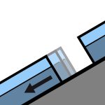
SnowpackThe old snowpack contains various weak layers. In particular on wind-sheltered shady slopes, surface hoar is in some cases covered by snow. Deeper in the snowpack there are faceted layers, which in isolated cases are still prone to triggering, especially on seldom-used slopes with little snow cover. As daytime temperatures rise and the surface starts to moisten, in some places, the likelihood of even dry avalanches being triggered is increasing during the course of each day.Moreover, all regions can expect to see wet snow avalanches over the course of each day. Isolated wet slab avalanches may also be triggered by human activity. Gliding avalanches are to be expected mainly north of a line from the Rhône to the Rhine and also mostly tend to occur as the day progresses.
Source: SLF
Original (EN)
Frequently asked questions
What does avalanche danger level 1 (Low) mean?
Generally favourable conditions — avalanches are possible mainly with high additional load on very steep terrain.
How often is the Bienne - Neuchâtel forecast updated?
Avycast refreshes hourly; the bulletin is republished by SLF usually once a day during the season.
Who publishes the Bienne - Neuchâtel avalanche forecast?
SLF — the official warning service. Avycast aggregates and translates it; always check the original bulletin.
Nearby Regions
- Vallon de Saint-Imier · 18 km
- Val de Ruz - Colombier · 26 km
- Bex-Villars · 26 km
- Liechtenstein · 28 km
- Schächental · 38 km
- Blüemlisalp · 47 km